High clouds: Cirrostratus
Ecosystems - Meteorology, Climate

High clouds: Cirrostratus
Illustration of cirrostratus clouds, thin, generally uniform clouds, composed of ice-crystals, capable of forming halos. When thick enough to be seen, they are whitish, usually with no distinguishing features
High clouds: Cirrostratus
Related Symbols


. Nimbo is from the Latin word")
Middle clouds: Nimbostratus 1
Illustration of a nimbostratus cloud, a rain cloud characterized by a formless layer that is almost uniformly dark gray, of medium altitude, usually developing above 6500 ft (2000 m). Nimbo is from the Latin word "nimbus" meaning rain. They may block a great amount of sunlight as a result of their characteristic dense structure
Middle clouds: Nimbostratus 1

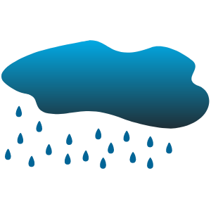
Weather: sheeting rain
 Each cloudlet appears no larger than a finger held at arms length. It occurs in patches or sheets, organized in rows like other cumulus, but since they are so small, cirrocumulus patches take on a finer appearance, sometimes referred to colloquially as")
High clouds: Cirrocumulus
Illustration of a cirrocumulus cloud, a large, white patch or tuft without a gray shadow. Composed of supercooled liquid droplets (if they freeze, becomes cirrostratus - cirrocumuli are short lived) Each cloudlet appears no larger than a finger held at arms length. It occurs in patches or sheets, organized in rows like other cumulus, but since they are so small, cirrocumulus patches take on a finer appearance, sometimes referred to colloquially as "herringbone" or "mackerel"
High clouds: Cirrocumulus


Middle clouds: Altocumulus 1
Illustration of a cloud belonging to a class characterized by globular masses or rolls in layers or patches. Alto, "high", cumulus, "heaped". Usually white or gray, and often occurs in sheets or patches with wavy, rounded masses or rolls. Often are seen preceding a cold front, and their presence on a warm, humid, summer morning frequently signals the development of thunderstorms later in the day