Cold Front
Ecosystems - Meteorology, Climate

Related Symbols


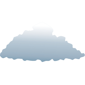
Middle clouds: Altocumulus 1
Illustration of a cloud belonging to a class characterized by globular masses or rolls in layers or patches. Alto, "high", cumulus, "heaped". Usually white or gray, and often occurs in sheets or patches with wavy, rounded masses or rolls. Often are seen preceding a cold front, and their presence on a warm, humid, summer morning frequently signals the development of thunderstorms later in the day
Middle clouds: Altocumulus 1


Low clouds: Stratocumulus 1
Illustration of stratocumulus clouds, belonging to a class characterized by large dark, rounded masses, usually in groups, lines, or waves. Weak convective currents create shallow cloud layers because of drier, stable air above preventing continued vertical development. Vast areas of subtropical and polar oceans are covered with massive sheets of stratocumuli
Low clouds: Stratocumulus 1

Low clouds: Cumulus 1
Illustration of a cumulus cloud, a cloud with noticeable vertical development and clearly defined edges. Cumulus means "heap" or "pile" in Latin. They are often described as "puffy" or "cotton-like" in appearance. Cumulus clouds typically form when warm air rises and reaches a level of comparatively cool air, where the moisture in the air condenses. This usually happens through convection, where a parcel of air is warmer than the surrounding air
Low clouds: Cumulus 1

Low clouds: Stratus 1
Illustration of stratus clouds, meaning layer or blanket in Latin. Characterized by horizontal layering with a uniform base. Flat, featureless clouds of low altitude varying in color from dark gray to nearly white obscuring the disk of the sun. Essentially above-ground fog formed either through the lifting of morning fog or when cold air moves at low altitudes over a region
Low clouds: Stratus 1
 name of mare's tail. Cirrus clouds are formed when water vapor freezes into ice crystals at altitudes above 8000 meters (26,000 ft). Due to the sparse moisture at a high altitude, they tend to be very thin")
High clouds: Cirrus
Illustration of cirrus clouds, which are characterized by thin, wisplike strands, often accompanied by tufts, leading to their common (non-standard) name of mare's tail. Cirrus clouds are formed when water vapor freezes into ice crystals at altitudes above 8000 meters (26,000 ft). Due to the sparse moisture at a high altitude, they tend to be very thin
